OUR PROPOSAL
PROPOSED NEW NEIGHBOURHOOD COMPRISING MARKET AND AFFORDABLE HOMES INCLUDING THE POTENTIAL FOR AN 80 BEDROOM CARE HOME, PUBLIC OPEN SPACE, LANDSCAPING AND HIGHWAY IMPROVEMENTS ON LAND NORTH OF WATLING STREET AND WEST OF SIR ROBERT PEEL COMMUNITY HOSPITAL
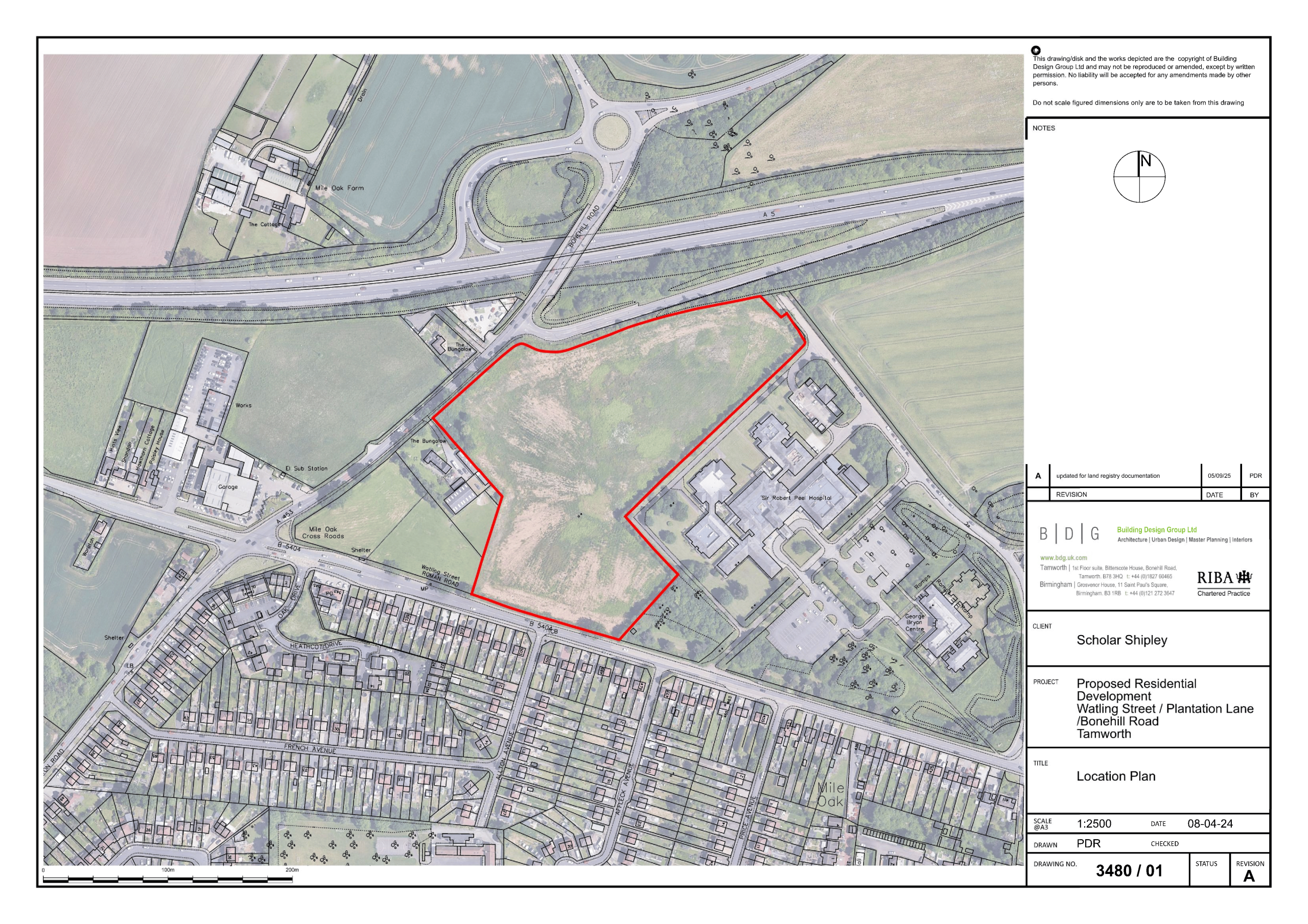
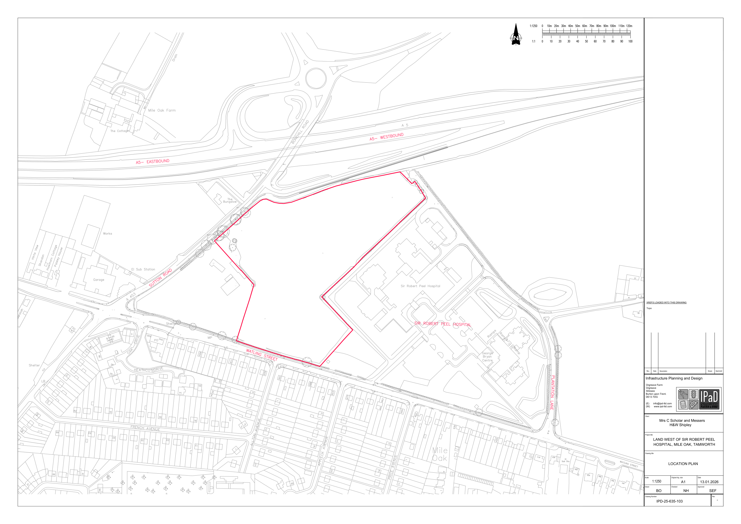
An outline planning application is proposed to be submitted to Lichfield District Council as the local planning authority, in April 2026 involving approximately 4.3 hectares of land adjacent to Watling Street and west of Sir Robert Peel Hospital at Mile Oak, Fazeley (see Map 1). The proposals are currently subject to pre-application discussions with the local planning authority and Staffordshire County Council as the highway authority. The Applicants, Ms Charlotte Schollar, Messrs. H. and W. Shipley, are local to the area and have assembled an extensive project team which using the best available evidence, to design the most appropriate development on the site taking into account its size, condition and relationship to surrounding land uses.
Map 1: Proposed application site
As part of this process, it is important that the views of people living and working in the locality of the site are consulted on the proposals and provided with an opportunity to provide comments and feedback on what is currently proposed on the site.
In summary two options for the development of the Site are under consideration:
Option A: Up to 118 dwellings together with a care home accommodating up to 80 bedrooms, together with 1 hectare of natural greenspace incorporating public open space, landscaping and biodiversity enhancements.
Option B: Up to 142 dwellings together with 1 hectare of natural greenspace incorporating public open space, landscaping and biodiversity enhancements.
In respect of both options, permission will be sought to confirm that the principle of development is acceptable. This will include illustrative layouts indicating the extent of development proposed. It will also seek detailed approval of the proposed access onto Watling Street. All other matters relating to the detailed layout including the design of the houses, care home and landscaping would be subject to a ‘reserved matters’ application to the local planning authority. At this stage therefore the principle of developing the Site is being sought.
Both schemes will include a mix of housing types and tenures, including 50% affordable homes.
Existing trees and the majority of existing hedgerows will be retained and enhanced with new planting. The development will deliver significant biodiversity improvements, enhancing its importance for nature and including extensive new tree planting.
Public open space and play facilities will also be provided which will be accessible to all.
SITE CONTEXT
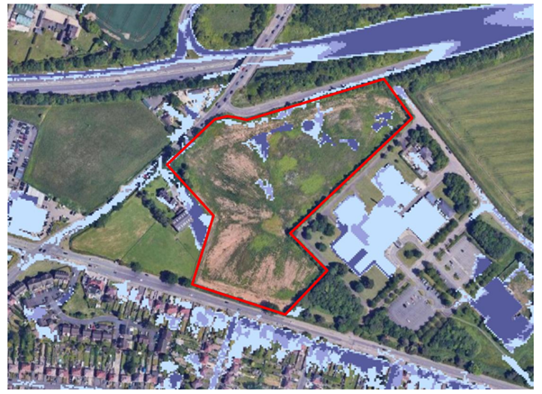
The Site extends to approximately 4.16 hectares (10.8 acres) and is located to the west of the Sir Robert Peel Community Hospital on the northern edge of the village of Mile Oak along Watling Street (B5404) and is located within the West Midlands Green Belt. The Site is unused and comprises a mix of grassland and scrub with a mature tree belt and hedgerows located along the northern, eastern and southern boundaries of the Site. However, none of these trees are protected under a Tree Preservation Order (‘TPO’).
In terms of accessibility, several bus stops are located along Watling Street (B5404), which provides regular services into Tamworth, Sutton Coldfield and Birmingham city centre via bus service 110. The Site would be served by Watling Street (B5404) and Sutton Road (A453), which connects to the Fazeley – Two Gates- Wilnecote Bypass (A5) and has direct links to the A38, the M6 Motorway and the M42 Motorway.
For the avoidance of doubt, the Site does not have any other non-statutory, statutory or Local Plan designations. In terms of flood risk, the Site falls wholly within Flood Zone 1 (i.e. the lowest risk of flooding) for both fluvial and surface water flooding, according to the
Environment Agency’s Flood Mapping Database. The Site is not surrounded by any historically sensitive development, and there are no Listed Buildings located within the vicinity of the Site.
It is relevant to note that the Site was historically planned to be utilised as part of the hospital’s development, which was initially scheduled to provide Accident and Emergency (‘A&E’) services. However, the ultimate design and development excluded this facility, and the land was subsequently acquired by the Applicants.
CONSIDERATIONS WHICH HAVE INFORMED THE PROPOSED DEVEOPMENT
The Site is located within the Green Belt and the implications of this designation are considered under Planning Policy Context. The Site has been promoted through the Lichfield District Council’s Local Plan process as part of the Lichfield Local Plan 2043 – Issues and Options Consultation (Regulation 18) (October 2024). As part of the Council’s consideration of the need to accommodate additional land for housing, its suitability was considered as part of a Stage 2 Green Belt Review (March 2021). This concluded that the Site played a ‘minor’ role in fulfilling Green Belt purposes and recommended that its suitability for housing should be progressed.
Currently the Council is preparing to publish a draft Lichfield Local Plan 2043 in May 2026 which will require sites to be identified to accommodate the need for additional housing. Currently the Council is unable to demonstrate a five -year supply of housing land which is required in order to ensure that local needs, including affordable housing needs, are met. Moreover the Applicant’s have commissioned specialist research which also confirms that there is a need for additional nursing and residential care beds within the District.
The application Site provides the opportunity to contribute towards meeting these needs in a sustainable location and on a site which is well defined by existing roads and built development.
PLANNING POLICY CONTEXT
Fazeley including Mile Oak is defined a Key Rural Settlement where new rural housing will be directed. Core Policy 6 of the adopted Local Plan (2015) confirms that development will be focused in Key Rural Settlements.
The application Site falls outside of a defined settlement boundary as confirmed within the Council’s Polices Map (2015) and therefore forms part of the countryside. However since the Local Plan was adopted, national policy guidance now requires that within Lichfield District 782 dwellings per annum should be provided compared with the 478 dwellings per annum provided for in the adopted local plan. On this basis it is considered that the spatial policies in the Local Plan which relate to the amount of new housing required, are out-of-date.
The Site’s location within the West Midlands Green Belt has also been examined and an assessment has been made as to whether it meets the definition of ‘grey belt’ within national planning policy. The definition as to what constitutes ‘grey belt’ land requires a consideration of three of the five purposes of the Green Belt. These are discussed below:
1. to check the unrestricted sprawl of large built-up areas
The Site does occupy land between Tamworth to the north-east and Royal Sutton Coldfield to the south-west. These settlements do not lie within Lichfield District but it is necessary to consider the potential for the proposed development on the unrestricted sprawl of these two towns, which comprise large built up areas. What is important to note is that Tamworth’s urban edge lies approximately 1.3kms from the Site and in the context of the PPG, the Site does not lie adjacent to this area. Nor is it considered to be ‘near’ to the urban edge. Consequently the site does not perform a function of checking the unrestricted sprawl or large built up areas.
2. to prevent neighbouring towns merging into one another
This applies to towns and not to villages and as confirmed under a) above the Site does not neighbour the towns of Tamworth and Sutton Coldfield
3. to preserve the setting and special character of historic towns
The Site does not lie adjacent to or within the setting of an historic town. Nor does it have any visual, physical, or experiential connection to the historic aspects of an historic town, the nearest within the District being Lichfield City. Accordingly, the proposed development does not conflict with this purpose
In terms of its impact on other Green Belt purposes including safeguarding the countryside from development and supporting urban regeneration including the recycling of derelict and urban land, the following points have been considered:
Although located within the Green Belt, the site is physically and visually separated from the wider countryside by major road corridors and surrounding development, and it does not contribute meaningfully to Green Belt openness or rural character.
– Visual effects are largely restricted to short-range views from the immediate surroundings, particularly from a small number of dwellings on Watling Street and Affleck Avenue where initial effects range from moderate to major–moderate due to partial visibility and the removal of part of an existing hedgerow. These impacts reduce substantially over time as proposed frontage planting establishes, with residual effects typically reducing to slight or minimal, and only the closest residential receptors experiencing any remaining Moderate effect.
– For the majority of other receptors—including public rights of way, road users, canal towpath users, and more distant residential properties— either no views of the development are possible, or views are so limited, filtered, or distant that effects are Minimal or Negligible both during construction and in the long term.
– From a landscape perspective, the site exhibits low sensitivity due to its derelict condition, lack of intrinsic landscape value, and influence from adjacent busy transport routes, built form, and urban activity. The magnitude of change arising from development is assessed as medium, resulting in a slight significance of effect at the site level. The wider landscape character experiences only a negligible magnitude of change and a minimal significance due to the site’s separation from the broader, more intact landscape areas.
– The proposals incorporate extensive mitigation planting—including new oak trees along Watling Street and substantial native planting to the north and west—which will enhance local green infrastructure, improve boundary definition. Overall, the development results in limited and acceptable visual and landscape effects, with the majority of impacts reducing to minimal, negligible, or slight once mitigation matures. The proposals do not undermine the purposes or openness of the Green Belt, and the landscape and visual changes are minor and localised, with no significant adverse impacts on the wider area.
– It is important to note that the Council’s ability to meet its housing land targets for market and affordable dwellings, can only be achieved through the use of greenfield sites given the limited amount of previously developed land which is potentially available and suitable. Additionally since the Green Belt relates to the whole of the West Midlands conurbation, there is greater scope within other authorities including Birmingham City, for the delivery of urban regeneration and the re-use/recycling of derelict land.
The scheme has also been designed in order that the ‘golden rules’ applying to housing development on grey belt sites are met as set out in the table below:
Table 1: Contribution to the ‘Golden Rules’
|
Golden Rule |
Contribution |
|
Affordable housing |
The Council’s Policy H2 ‘Provision of Affordable Homes’ confirms the Council’s commitment to improving housing affordability and sets a target of up to 40% of new dwellings to be provided as affordable housing. Outside of the main urban areas of Lichfield City and Burntwood, affordable housing will be required on housing developments in line with nationally set thresholds. Consequently in accordance with paragraph 157 of the NPPF, 50% of the proposes houses will be affordable. |
|
Improvements to local or national infrastructure |
No improvements to local or national infrastructure have currently been identified. It will however contribute to improved and publicly accessible green space including formal and informal recreational facilities. If other contributions are required towards education, health or highways these can be delivered. |
|
New or improved green spaces accessible to the public |
An ‘Open Space Assessment’ prepared on behalf of the Applicants recommends applying a standard of 1.43ha of amenity green space per 1,000 people to satisfy this contribution. This requires the provision of between 0.5ha-0.7ha of open space. In addition a Local Area for Play (LAP) is also proposed. This provision can be made within the 1ha of green space which is proposed along the northern and eastern parts of the site to satisfy this contribution. In the absence of any public footpaths across or linking to the Site, the proposed development will provide public access where none is currently available. This will include access to the green space and LAP. |
DESIGN AND LAYOUT
The outline planning application will seek permission for a new access from Watling Street. However all other matters relating appearance, landscaping, layout and scale are reserved and would be subject to detailed approval in the event that out permission is granted. At this time further public consultation would occur.
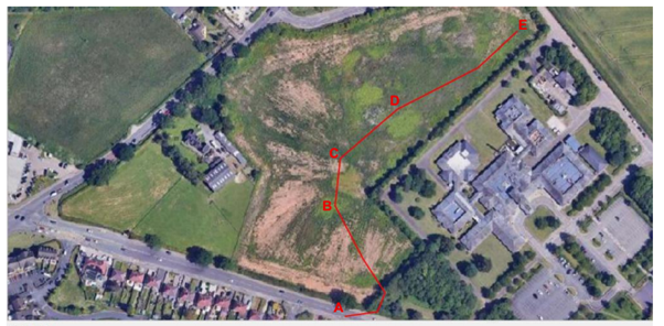
In order to inform the potential for the Site to accommodate the type of development proposed careful consideration has been given to the existing constraints including the proximity to Sir Robert Peel Hospital, existing residents to the south of Watling Street, the dwelling along the western boundary and the A5 road to the north.
Map 2: Existing site constraints
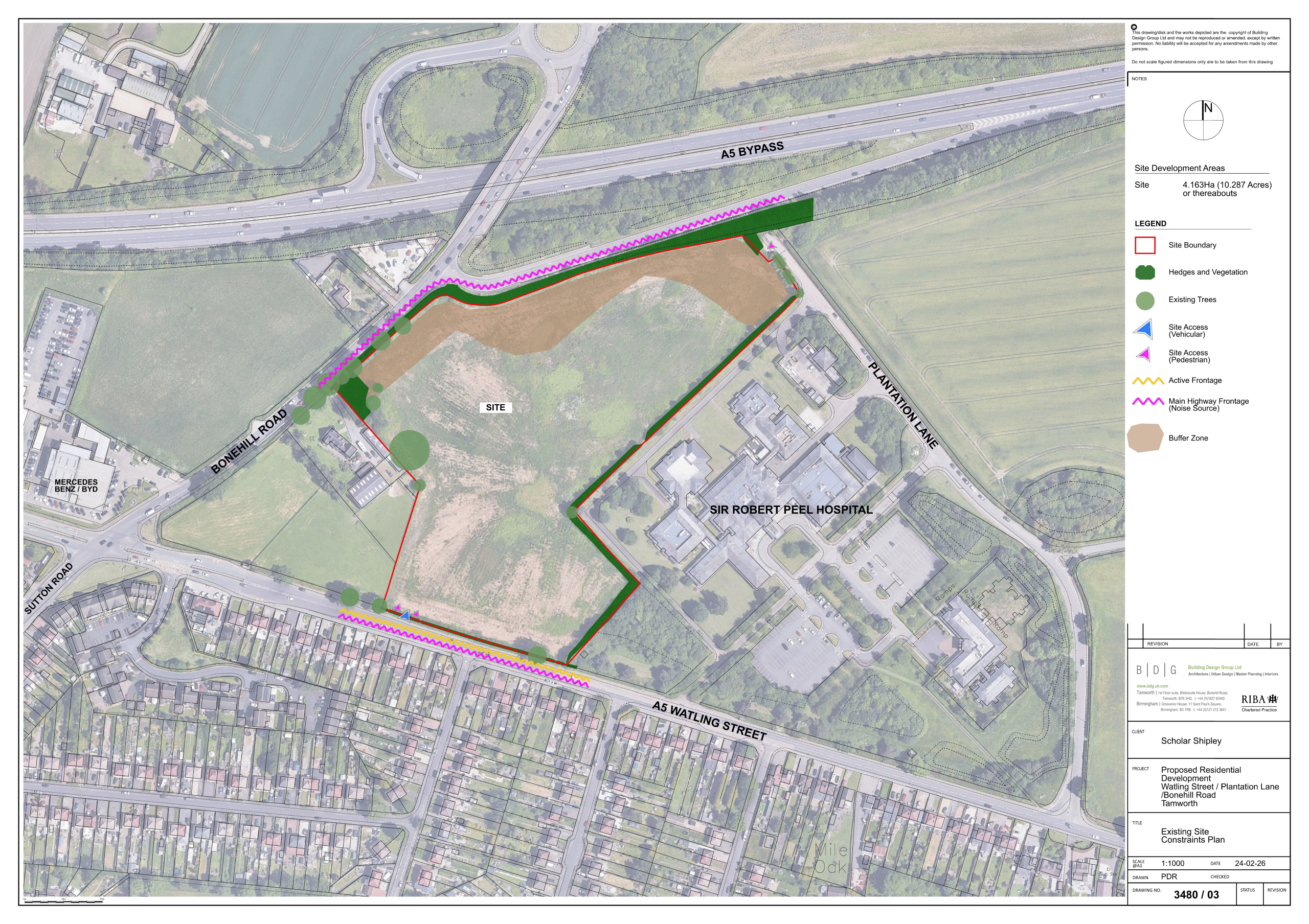
The Site benefits from being well contained and can be accessed directly from Watling Street without the need for a secondary access from Plantation Lane to the east of the hospital.
Two alternative layouts are proposed:
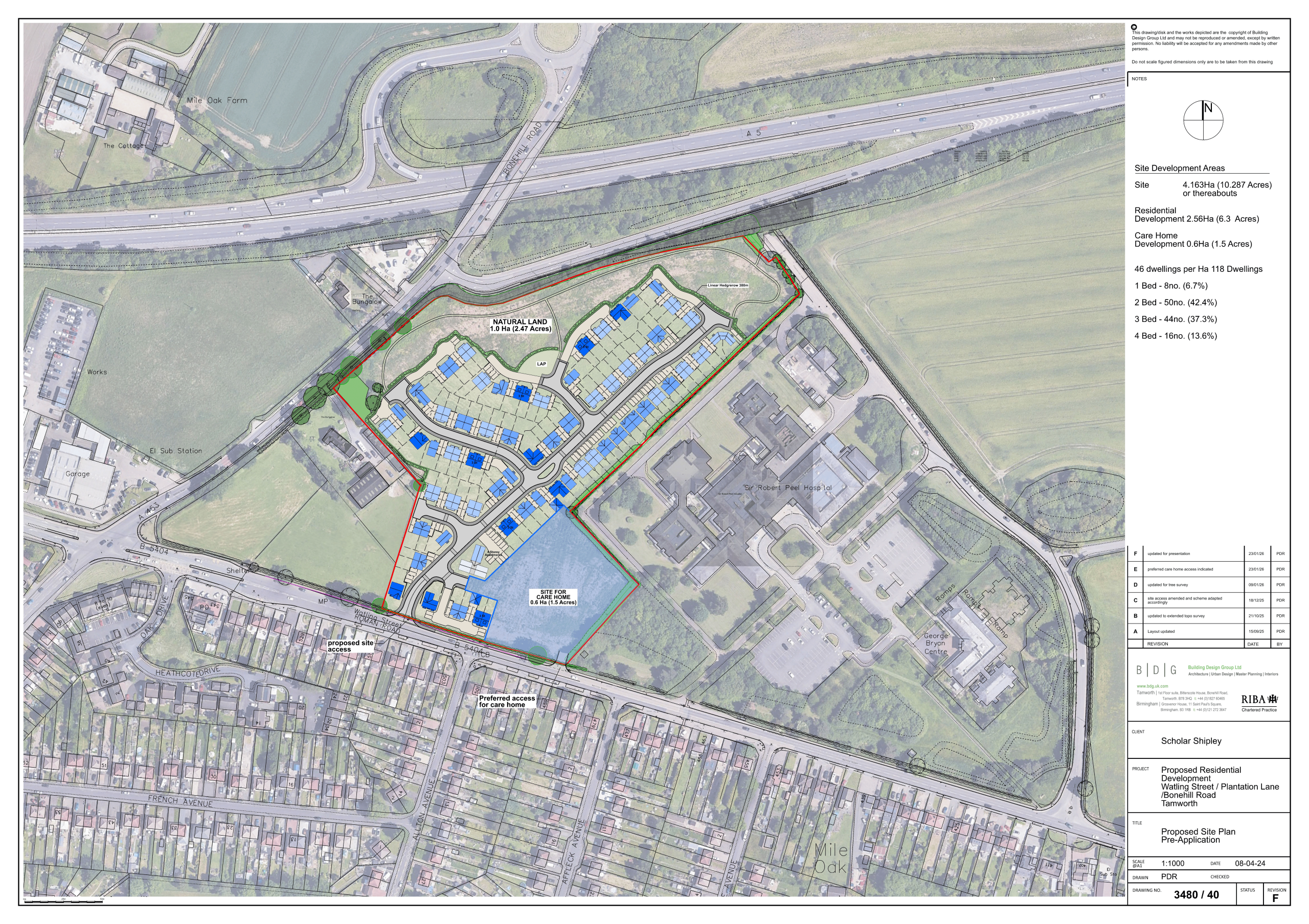
Option A: Up to 118 dwellings together with a care home accommodating up to 80 bedrooms, together with 1 hectare of natural greenspace incorporating public open space, landscaping and biodiversity enhancements.
Map 3: Option A – Illustrative layout
Option B: Up to 142 dwellings together with 1 hectare of natural greenspace incorporating public open space, landscaping and biodiversity enhancements.
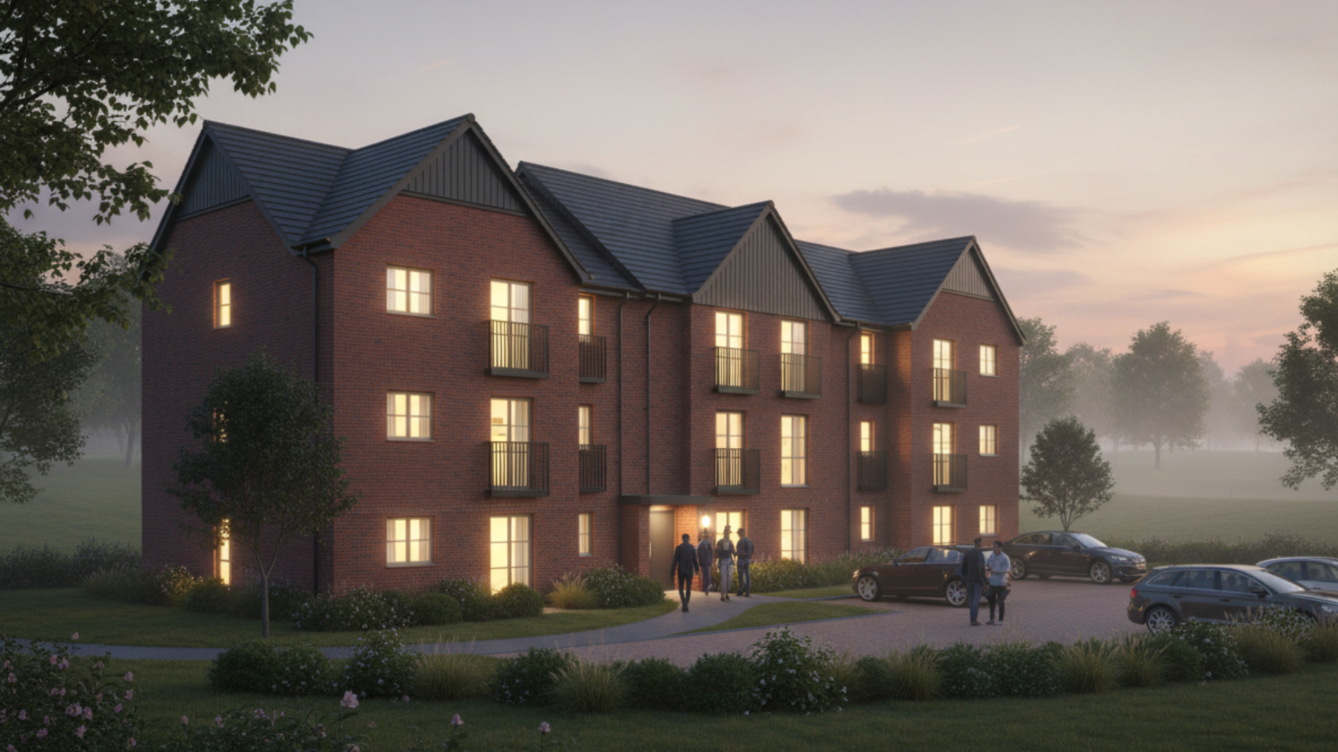
In respect of both Options A and B, the opportunity to introduce a limited number of 1 and 2 bedroom flats (see Image 1) will be included in order to provide greater variation in the townscape and urban form of the new neighbourhood.
Image 1: Illustration of potential 1-2 bedroom, three storey flats
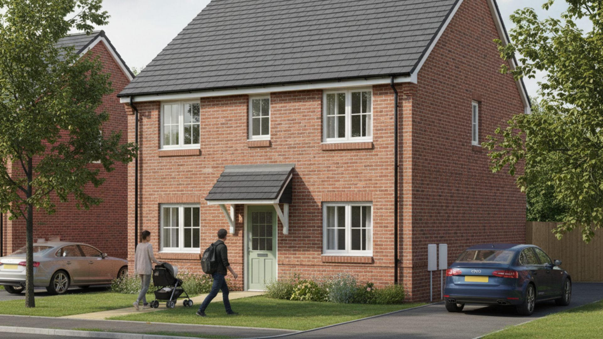
However the majority of the dwellings will comprise two storey, semi-detached and detached dwellings (see Images 2 and 3)
Image 2: Illustration of semi-detached dwellings
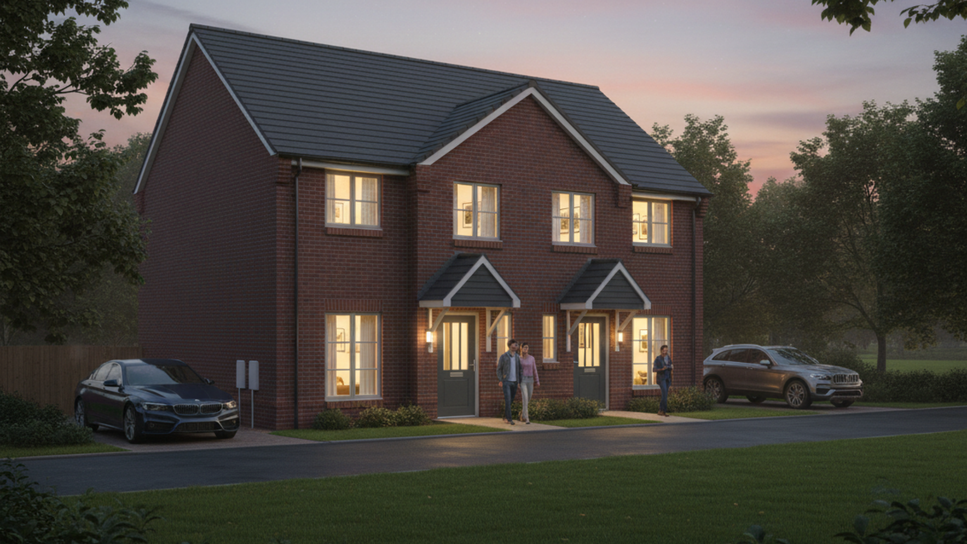
Image 3: Illustration of detached dwelling
Map 4: Option B – Illustrative layout

ACCESS AND TRANSPORATION
The local highway network surrounding the Site is managed and maintained by Staffordshire County Council (SCC), which comprises of the following surrounding roads.
Map 5: Main road context plan
Watling Street
A classified B-road (B5404) with a largely urban two-way single lane carriageway, routing on an east to west alignment and subject to a 40-mph speed limit. This road makes for the southern boundary of the Site.
Plantation Lane
A single lane two-way carriageway routing on a north-west to southeast alignment connecting onto Watling Street to the south via a simple priority T-Junction. It primarily serves as an access road to Sir Robert Peel Hospital and is subject to a 30-mph speed limit. This road connects to the northern boundary of the Site.
Sutton Road
A classified A-road with a single lane two-way carriageway that routes on a north to south alignment. The speed limit of the road changes between 40mph and 60mph along its stretch. Sutton Road connects to the Royal Town of Sutton Coldfield to the south and onto the A5 to the north.
A5
A major trunk road on the strategic road network which provides onwards connections to local destinations such as Venture Retail Park and Tamworth Town Centre and onward connects to Lichfield as well as the M6.
Access to the Site can theoretically be taken from one of two roads, these being Watling Street or Plantation Lane, of which consideration has been given to both options in terms of a Site access arrangement.
To get a better understanding of traffic conditions along the highway network, Automatic Traffic Count (ATC) surveys were collected along Watling Street which has informed the junction design.
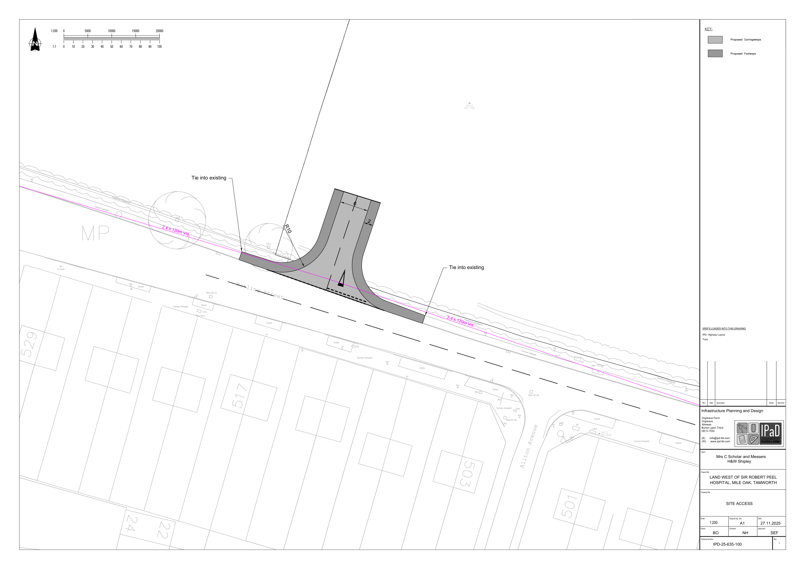
A simple priority T-Junction has been concluded to be the most appropriate form of junction to be placed along Watling Street for the primary access to the Site (Map 6). This would also keep in character with other junctions along Watling Street, such as the access with Plantation Lane to the East.
Map 6: Proposed junction onto Watling Street
Plantation Lane was also considered for a primary access however given the presence of on street parking, the proximity to Sir Robert Peel Hospital and the less direct/ more convoluted route to the site, a primary point of access in this location has not been pursued.
Based on the evidence above the Site’s primary access point is to be located off Watling Street. Consideration has then been made to the location of the access point in this location which has been informed by the relevant design standards and topographical survey data. The presence of a well-established oak tree located to the east of the southern site boundary constrains an access in this location and therefore the primary access point is to be located along the western boundary of the Site.
To maximise sustainable access the site access will provide footways onto Watling Street which enhance accessibility to surrounding areas including direct access to the bus stop directly west of the access. All internal roads will be provided with kerbside footways.
The proposed development Site is within walking and cycling distance of several off-site key services and facilities such as schools, commercial food retail, and employment land. A bus service is also available within 400 metres walk from the site that can provide local journeys between the site and Tamworth and Birmingham.
The delivery of the Site will also be subject to the implementation of a Residential Travel Plan to further bolster and promote the sustainable travel options available to future residents.
GREEN INFRASTRUCTURE
Croft Ecology has undertaken an ecological assessment of the Site. This walkover survey mapped the existing habitats on the Site (see Map 7), including a botanical survey and assessment for protected species which may use the site, such as bats, badgers and animals which may use the Site for foraging and commuting.
Map 7: Baseline survey of existing habitats
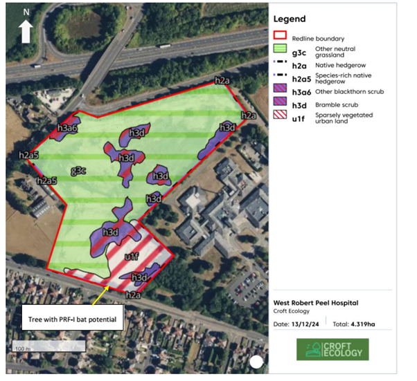
The scheme has been designed to deliver an area of open space at the north of the Site, and it is proposed to retain several features of value – including mature trees at the south west boundary and the majority of boundary hedgerows. This area will also be landscaped and will be available as public open space which will include new tree planting and footpaths. It will also enable the Site’s ecological value to be enhanced.
Croft Ecology have worked with the landscape architect for the scheme to inform the current proposals such that biodiversity enhancement is delivered in parallel with the delivery of new landscaping and open space.
Biodiversity Net Gain calculations will inform the scheme design such that the proposals deliver a benefit for nature once completed. Where on Site delivery is not possible, off-site compensation will be sought.
Proposals will include ecological enhancements such as bat and bird boxes, hibernacula, invertebrate boxes and sensitive lighting such that animals can continue to use the Site and wider landscape.
An illustrative landscape scheme has also been prepared (see Map 8). It is proposed that native and ornamental tree and hedge planting will enhance the visual amenity and character of the Site in addition to contributing to enhancing its ecological value.
FLOOD RISK AND DRAINAGE
The Site is located in Flood Zone 1, the lowest risk zone, on the Environment Agency’s Flood Map for Planning. The Environment Agency’s surface water flood risk map (Map 9 – which includes the effects of future climate change) reveals a few localised areas to the north of the Site where rainwater may collect. A significant part of the north part of the Site will be set aside for greenspace. Where development is proposed, the isolated low spots will be lost as the Site is regraded for the development. The future development will also include a SuDS drainage scheme in line with current good practice.
Map 9: The Environment Agency’s surface water risk map for 2040 to 2060
All other sources of flooding have also been considered. No specific flood risk has been identified that warrants escalated flood management measures beyond normal good building practices.
- Drainage
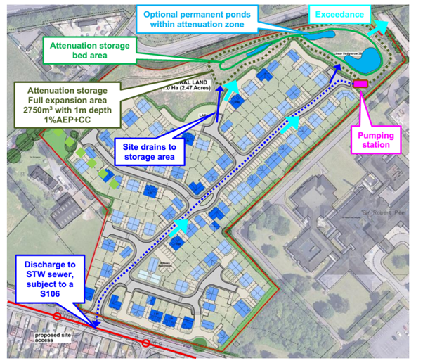
The proposed surface water drainage strategy is planned to include the following elements (see Map 10):
- Incorporate source control components within the development as far as possible, subject to the final layout.
- Collect surface water from the proposed development and drain by gravity to a Sustainable Urban Drainage System (SuDS) attenuation scheme within the greenspace.
- Design and construct a SuDS attenuation scheme that is capable of managing 2750 cubic metres of water.
- Control the flow rate exiting the SuDS attenuation scheme via a suitably designed pumping station with a rate controlled to a maximum to be agreed with the Local Lead Flood Authority.
- Design the development with safe flow paths along roads such that exceedance flooding can safely flow north-east to the greenspace, and ensure no on-site flood risk arise.
Map 10: Proposed surface water drainage system
Foul water will be discharged to the 225mm combined public sewer on Watling Street. Severn Trent have confirmed that there is capacity available within their system for this and can be achieved by gravity discharge for the most southerly part of the development however a pumped system will be needed for the north part of the development (see Map 11).
Map 11: Foul drainage connection
NOISE AND AIR QUALITY
- Noise
The susceptibility of the development to potential external noise impact has been assessed. The results of the survey, including observations made during site visits, indicate that the general noise climate across the Site and surrounding area is determined by traffic on Watling Street, Sutton Road and the Wilnecote Bypass and slip road. No audible activity from either the stables to the west or the hospital to the east was recorded.
Overall no unacceptable levels of noise with mitigation for dwellings in closest proximity to the noise sources, is predicted to arise in respect of residents living in the proposed dwellings or care home.
- Air quality
The application Site is not located within an Air Quality Management Area, the closest being 5 kilometres to the south-west within Birmingham. Residents living with the proposed development would not therefore be subject to any unacceptable levels of nitrogen dioxide or air borne particulates. Nor will traffic generated by the proposal have a material impact on local air quality.
During the construction phase, dust and particulates would be generated and it is proposed that a planned mitigation strategy would ensure that the impact would not be significant. In addition any such impacts would be temporary and short-term in nature.
OVERALL CONCLUSIONS
The Site offers the opportunity to deliver a high quality neighbourhood involving a range of market and affordable dwellings together with the potential inclusion of an 80-bed care home.
It is well related to Mile Oak and Fazeley, a designated Key Rural Settlement, and represents a sustainable and logical extension to the settlement. It has also been identified as a potential allocation through two previous plan‑making exercises.
Comprehensive technical assessments demonstrate that the Site is suitable for development, and that no insurmountable constraints exist. Landscape effects would be limited and the proposal is considered to involve an appropriate scale and type of development which would be compatible with the character and appearance of the wider area and with the role and function of its location at a Key Rural Settlement.
THE NEXT STEPS
Currently the intention is to submit the outline planning application in April 2026 in order to enable the Council and local residents together with interested parties the opportunity to formally consider the merits of the proposed development.
The consultation undertaken by the Applicants will enable feedback on the proposals to be considered and as appropriate, include amendments to be made. This will also include feedback on pre-application discussions with Lichfield District Council and Staffordshire County Council as highway which have yet to be concluded.
Your comments can be provided via this web page or by post to:
MWA
12 The Glenmore Centre
Jessop Court
Waterwells Business Park
Quedgeley
Gloucester
GL2 2AP
Comments should be provided by Friday 5th April 2026. However any comments after this date will be summarised and provided to Lichfield District Council as part of the application process.
This consultation does not replace the Council’s approach to the publicity and consultation on the application (once submitted) as set out in its ‘Statement of Community Involvement’ (July 2025) which is available on the Council’s web site at:
https://www.lichfielddc.gov.uk/downloads/file/2975/statement-of-community-involvement